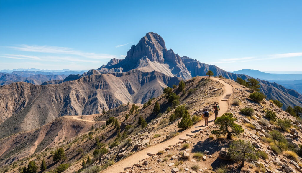
Guadalupe Mountains National Park: Guide to Hikes & Peaks
Most people driving through West Texas never realize the state’s highest summit hides just an hour east of El Paso. Guadalupe Mountains National Park gets overshadowed by its famous neighbor to the east, but visitors who make the detour discover something rare in the American Southwest: genuine quiet. With eight of Texas’s ten highest peaks contained within its boundaries, this park offers altitude changes that can genuinely alter your frame of mind.
Highest Peak: Guadalupe Peak at 8,751 feet · Texas Peaks: Eight of ten highest in park · Fossil Reef: World’s most extensive Permian · Status: Least visited national park in Texas · Main Hike Elevation Gain: 3,000 feet to summit
Quick snapshot
- Eight highest Texas peaks sit within the park (Shaka Guide itinerary)
- Guadalupe Peak rises to 8,751 feet — the highest point in Texas (Hiking Guy trail guide)
- Park has 80+ miles of maintained trails (National Park Service official hiking page)
- Exact annual visitor counts by year have limited public disclosure
- Optimal month for solitude has minimal documented comparison
- Spring surge runs March through May; fall surge September through December (NPS busy periods page)
- October draws peak crowds for McKittrick Canyon foliage (NPS busy periods page)
- Fall visitors should plan permits and camping reservations early
- Park infrastructure remains sized for lower visitation — expect availability outside peak windows
The table below consolidates the essential park facts travelers need before planning a visit.
| Detail | Value |
|---|---|
| Location | East of El Paso, Texas |
| Highest Point | Guadalupe Peak 8,751 ft |
| Key Attraction | Permian fossil reef |
| Visitor Status | Least visited in Texas |
| Main Trail Gain | 3,000 feet to summit |
Is it worth going to Guadalupe Mountains National Park?
The answer depends on what you’re after. If you want blockbuster scenery and crowded overlooks, steer toward Big Bend two hours east. But if your ideal national park visit involves actually hearing the wind rather than other visitors’ conversations, Guadalupe Mountains delivers something increasingly rare: genuine wilderness within a day’s drive of a major city.
Upsides
- Least crowded Texas national park means trails feel genuinely remote
- Eight of the state’s ten highest peaks create dramatic elevation change
- Over 80 miles of trails range from easy nature walks to strenuous summit pushes
- The Permian fossil reef offers a one-of-a-kind geological feature
- Park infrastructure remains sized for lower visitation — parking and campgrounds rarely fill outside October
Downsides
- Summer heat at lower elevations can make hiking dangerous without preparation
- Remote location means limited services — fill your tank and bring all supplies
- Water sources are scarce on trails; carry at least one gallon per person per day
- McKittrick Canyon gate operates 8 AM to 5 PM, limiting flexibility
- Winter brings snow and ice at high elevations requiring extra caution
Visitors who complete the Guadalupe Peak summit describe views that rank among the most rewarding in the American Southwest. Tripadvisor reviewers note: “The views from Guadalupe Peak are incredible, worth every mile of the climb.” The National Park Service describes the experience as a chance to let “altitude change your attitude.”
What is special about Guadalupe Mountains National Park?
The park’s defining feature is geological and geographical in equal measure. Beneath these mountains lies the world’s most extensive Permian fossil reef, a 250-million-year-old limestone formation that grew in a shallow sea covering what is now the Chihuahuan Desert. Above ground, eight of Texas’s ten highest peaks concentrate within a relatively small boundary, creating an island of alpine terrain in a sea of desert.
Highest peaks in Texas
Guadalupe Peak anchors the collection at 8,751 feet, making it the highest point in Texas. El Capitan stands just over 8,000 feet nearby. The Pine Springs trailhead serves as the departure point for the signature summit hike, which covers 8.4 miles round trip with 3,000 feet of elevation gain. According to the National Park Service, the Guadalupe Peak Trail is a “rewarding, and very strenuous” route to what they call “the Top of Texas.”
Permian fossil reef
The Permian fossil reef represents a window into an ancient sea that once covered this region. Unlike many fossil sites that require expert knowledge to appreciate, the reef’s bones are visible in cliff faces and canyon walls throughout the park. Trail guides point out formations where ancient marine creatures left their imprints in limestone that once formed the seafloor.
Serene forests and history
Above the desert floor, canyons catch more moisture and support stands of pine, juniper, and oak that seem out of place in the Chihuahuan Desert. McKittrick Canyon becomes particularly striking in fall when maple trees turn gold and crimson against the limestone backdrop. The Hunter Line Shack and Pratt Cabin offer historic waypoints along longer routes, remnants of the ranching era before the park’s establishment.
The combination of Permian fossils and Texas’s highest summit within a single park boundary is genuinely unusual. Most states with significant geology sacrifice accessibility for diversity. Guadalupe Mountains offers both in a package that rewards hikers willing to tackle the elevation changes.
What is the least visited national park in Texas?
Guadalupe Mountains National Park holds the distinction of being Texas’s least visited national park, though exact annual visitation figures have limited public disclosure. The National Park Service acknowledges that the park “is often described as least-visited” and notes that its infrastructure was designed for lower visitation levels. This reality cuts both ways: the solitude is genuine, but services and facilities remain scaled accordingly.
Visitor numbers comparison
Big Bend National Park, the state’s other major national park, draws substantially more visitors despite requiring a longer drive from population centers. Guadalupe Mountains sits roughly an hour east of El Paso, a metro area of nearly a million people, yet the park receives a fraction of the traffic that similar-distance parks get elsewhere in the country.
Reasons for low crowds
Several factors explain the light visitation. The park lacks the iconic overlooks and Instagram-ready formations that drive social media shares. Trail access requires more commitment — the best features demand full-day hikes rather than roadside photo stops. Summer heat makes the desert portions genuinely hazardous, effectively closing the park for warm-weather tourists. The remote location, while manageable from El Paso, sits far from the Dallas-Houston corridor where most Texans live.
For visitors who prioritize solitude over spectacle, these same factors become selling points. The park offers something the busier parks cannot: space to breathe and trails that feel genuinely wild.
How many days should I spend at Guadalupe Mountains National Park?
Most visitors accomplish the highlights in a single full day, but backpackers and hikers targeting the longer routes benefit from two to three days. The Guadalupe Peak summit hike alone takes eight to ten hours round trip for most hikers, eating up an entire day when combined with driving and logistics. Those wanting to also tackle Devil’s Hall or McKittrick Canyon need additional time.
Suggested itineraries
A single-day visitor should prioritize the Guadalupe Peak Trail for the summit experience, leaving from Pine Springs before dawn to avoid afternoon heat and maximize daylight. The 8.4-mile round trip with 3,000 feet of elevation gain demands fitness and preparation but rewards completion with panoramic views spanning the Chihuahuan Desert.
Two days allows pairing Guadalupe Peak with either Devil’s Hall or McKittrick Canyon. Devil’s Hall offers a 4-mile round trip with boulder scrambling and a narrow corridor finale, rated moderate to difficult. McKittrick Canyon extends 4.8 miles to Pratt Cabin or 6.8 miles to the Grotto and Hunter Line Shack, with multiple riverbed crossings that can be tricky after rain.
Key activities per day
Day one: Guadalupe Peak summit push. Day two: either McKittrick Canyon for fall foliage or a shorter morning trail before departure. Overnight camping requires no day-use permit for Guadalupe Peak, but overnight stays require a backcountry permit from the Pine Springs Visitor Center.
Two days covers the signature experiences without rushing. One day works for fit hikers focused on the summit, but trying to pack everything into 24 hours means sacrificing the contemplative pace that makes the park special.
What is the best time to visit Guadalupe Mountains National Park?
The window between late September and early November typically offers the most compelling combination of mild temperatures and dramatic scenery, particularly for McKittrick Canyon’s fall foliage display. Autumn edges ahead when the maples turn, though the trade-off is crowd timing: October draws the year’s peak visitation for a park that usually sees very little.
Seasonal weather
Summer temperatures at lower elevations regularly exceed 100°F, making hiking dangerous during midday hours. The National Park Service recommends carrying one gallon of water per person per day and treating sun exposure seriously. Spring and fall bring warm, pleasant conditions to both desert and mountain zones. Winter conditions vary by elevation — the desert floor may see mild temperatures while Guadalupe Peak collects snow and ice requiring traction devices.
Best months for hiking
September through November offers the most comfortable hiking conditions, with daytime temperatures in the 60s and 70s at elevation. March through May provides similar comfort with the advantage of wildflower season in lower canyons. January, July, and August historically see the lowest visitation, likely reflecting January cold, July heat, and August combination of both.
Visiting for foliage means joining October crowds. Visiting for solitude means accepting either January cold, July heat, or August’s blend of both. Late September or early November offers a middle path: decent foliage viewing with reduced crowds before winter settles in.
“Hike to ‘the Top of Texas’ The trail to the summit of Guadalupe Peak is a rewarding, and very strenuous, 8.5 mile round trip hike with a 3,000 foot elevation gain.”
“We think the best time to visit Guadalupe Mountains National Park is during the spring (March–May) or fall (September–November), when temperatures are milder.”
Related reading: Jeep Grand Cherokee for rugged park access
visitguadalupemountains.com, schoandjo.com, tripadvisor.co.uk, whenyouwander.com, nps.gov
Frequently asked questions
What is the closest town to Guadalupe Mountains National Park?
Carlsbad, New Mexico sits about 35 miles north of the park’s visitor center, making it the nearest option for fuel and supplies. Van Horn, Texas lies roughly 70 miles east and offers basic services. El Paso, the nearest major city, lies about an hour west of the park entrance.
What is Guadalupe Peak?
Guadalupe Peak is the highest summit in Texas at 8,751 feet above sea level. The Guadalupe Peak Trail runs 8.4 miles round trip from the Pine Springs trailhead, gaining 3,000 feet of elevation along the route. Hikers who complete the out-and-back journey reach what the National Park Service calls “the Top of Texas.”
Guadalupe Mountains National Park weather?
The park experiences dramatic temperature variation by elevation. Desert floors see summer highs exceeding 100°F and winter lows below freezing. Higher elevations add 10-15 degrees of cooling and may see snow from November through March. Spring and fall offer the most moderate conditions, with highs in the 60s and 70s at summit elevation.
Guadalupe Mountains National Park camping?
The Pine Springs Campground offers first-come, first-served sites near the visitor center. Backcountry camping requires a free permit from the Pine Springs Visitor Center, available during business hours. No day-hike permit is required for Guadalupe Peak, but overnight stays require backcountry registration. McKittrick Canyon has limited backcountry sites accessible by the Pratt Cabin or Hunter Line Shack routes.
Guadalupe Mountains National Park elevation?
The park headquarters sits at nearly 5,700 feet elevation. Guadalupe Peak reaches 8,751 feet — the highest point in Texas. The elevation gain on the Guadalupe Peak Trail totals 3,000 feet from trailhead to summit, passing through desert scrub, canyon, and alpine terrain in a single hike.
Guadalupe Mountains National Park vs Big Bend?
Big Bend draws roughly ten times more visitors than Guadalupe Mountains despite requiring a longer drive from most Texas population centers. Big Bend offers more developed infrastructure, multiple scenic drives, and the Rio Grande for river activities. Guadalupe Mountains offers superior solitude, higher peaks, and the Permian fossil reef. Hikers prioritize trails; those wanting variety and amenities lean toward Big Bend.
What are the top hikes?
The Guadalupe Peak Trail ranks first for the summit experience. Devil’s Hall offers a 4-mile moderate-difficult route with unique boulder scrambling. McKittrick Canyon ranges from 4.8 to 6.8 miles depending on destination, with Pratt Cabin and Hunter Line Shack as historic waypoints. Pinery Trail provides an easier option, while Salt Basin Dunes adds variety for those wanting something completely different from the mountain routes.
Bottom line
For hikers and nature enthusiasts within driving distance of El Paso, Guadalupe Mountains National Park offers something increasingly scarce in the national park system: trails that feel genuinely uncrowded and scenery that rewards effort without crowds to diminish the experience. Visitors who invest in the elevation change—carrying adequate water, tackling the 3,000-foot gain, and timing their visit for the mild seasons—discover a West Texas gem that remains quietly one of America’s most underrated national parks.
More related posts
 E-ZPass Toll Text Scam: How to Spot and Report Smishing
 Guardian of the Galaxy Ca t Guide: Full Li t of Actor
 Smoky Mountain National Park: Best Time, Location & Tips
 Will SNAP Benefits Be Issued in November 2025 – Dates and Status
 Seychelles Chikungunya Outbreak: Travelers Face High Risk
 Card Shows Near Me: Find Events Today & This Weekend
 Air Fryer French Fries: Time, Temp, and Tips
 Isabel May Movies and TV Shows: Full Filmography List
